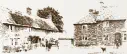
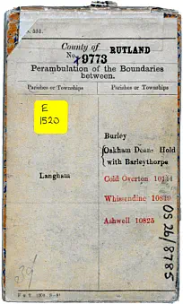
Following the 1841 election, the Ordnance Survey (OS) carried out a
survey of the local administrative boundaries for Great Britain which
was completed by 1888. The boundary between the parish of
Langham and its neighbouring parishes of Ashwell, Burley, Oakham
Deans Hold with Barleythorpe, Cold Overton (Leicestershire) and
Whissendine was surveyed between 1878 and 1883. See the
interactive parish boundary map and view the survey book pages.
Each parish appointed its own ‘Meresman’ who had considerable
local knowledge, to work colaboratively with the OS surveyor
(usually a military engineer) and Meresmen from the adjoining
parishes to agree, rather than impose, the boundary and record
the results in survey books now held by the National Archives.
Thomas Nettleship was the Meresman and Assistant Overseer for
the Parish of Langham and he collaborated with John S. Egan a
member of the Royal Engineers. Meresmen from the surrounding
parishes were: John Tidd - Ashwell, C.J. Bradshaw - Burley,
John Carter - Cold Overton, R.S Hayr - Oakham Dean’s Hold with
Barleythorpe and John Green - Whissendine.
Many of these areas had been in place for hundreds if not thousands of years. This work created
the first comprehensive cartographical record for the UK.
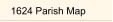
Langham is fortunate to have a number of detailed plans/maps of its Manor/Parish with the
earliest dated 1624. This was prepared to allow the Noel family, the estates new owners, to see
who held which fields and properties and the income derived from leases.
No plan of the open fields has yet been found but Terriers from 1605, 1618 & 1628 help to
identify the fields, who farmed where, and to decide when open fields became enclosed.
A second large map from 1760, although badly damaged, provides very detailed information
down to individual trees and in 1841 the tithe map and its apportionments update the situation.


Langham Village History Group ~ © 1996 - 2025


The Parish Boundary

Following the 1841 election, the Ordnance Survey (OS) carried out a
survey of the local administrative boundaries for Great Britain which
was completed by 1888. The boundary between the parish of
Langham and its neighbouring parishes of Ashwell, Burley, Oakham
Deans Hold with Barleythorpe, Cold Overton (Leicestershire) and
Whissendine was surveyed between 1878 and 1883. See the
interactive parish boundary map and view the survey book pages. 
 Each parish appointed its own ‘Meresman’ who had considerable
local knowledge, to work colaboratively with the OS surveyor
(usually a military engineer) and Meresmen from the adjoining
parishes to agree, rather than impose, the boundary and record
the results in survey books now held by the National Archives.
Thomas Nettleship was the Meresman and Assistant Overseer for
the Parish of Langham and he collaborated with John S. Egan a
member of the Royal Engineers. Meresmen from the surrounding
parishes were: John Tidd - Ashwell, C.J. Bradshaw - Burley,
John Carter - Cold Overton, R.S Hayr - Oakham Dean’s Hold with
Barleythorpe and John Green - Whissendine.
Many of these areas had been in place for hundreds if not thousands of years. This work created
the first comprehensive cartographical record for the UK.
Langham is fortunate to have a number of detailed plans/maps of its Manor/Parish with the
earliest dated 1624. This was prepared to allow the Noel family, the estates new owners, to see
who held which fields and properties and the income derived from leases.
No plan of the open fields has yet been found but Terriers from 1605, 1618 & 1628 help to
identify the fields, who farmed where, and to decide when open fields became enclosed.
A second large map from 1760, although badly damaged, provides very detailed information
down to individual trees and in 1841 the tithe map and its apportionments update the situation.
Each parish appointed its own ‘Meresman’ who had considerable
local knowledge, to work colaboratively with the OS surveyor
(usually a military engineer) and Meresmen from the adjoining
parishes to agree, rather than impose, the boundary and record
the results in survey books now held by the National Archives.
Thomas Nettleship was the Meresman and Assistant Overseer for
the Parish of Langham and he collaborated with John S. Egan a
member of the Royal Engineers. Meresmen from the surrounding
parishes were: John Tidd - Ashwell, C.J. Bradshaw - Burley,
John Carter - Cold Overton, R.S Hayr - Oakham Dean’s Hold with
Barleythorpe and John Green - Whissendine.
Many of these areas had been in place for hundreds if not thousands of years. This work created
the first comprehensive cartographical record for the UK.
Langham is fortunate to have a number of detailed plans/maps of its Manor/Parish with the
earliest dated 1624. This was prepared to allow the Noel family, the estates new owners, to see
who held which fields and properties and the income derived from leases.
No plan of the open fields has yet been found but Terriers from 1605, 1618 & 1628 help to
identify the fields, who farmed where, and to decide when open fields became enclosed.
A second large map from 1760, although badly damaged, provides very detailed information
down to individual trees and in 1841 the tithe map and its apportionments update the situation.


Langham Village History Group ~ © 1996 - 2025