John Ogilby was born in or near Kirriemuir, Scotland, in
1600 and was a man of many careers. His first venture
was that of a dancing teacher. A fall during a masque
(courtly entertainment), allegedly at Burley on the Hill,
Rutland, made him lame for the rest of his life and ended
that particular vocation. He next became a tutor, then
literary translator, a theatre owner, finally becoming a
printer and publisher. However, his last business came
to an abrupt halt when in 1666 disaster struck and his
premises in Fleet Street were destroyed in the Great Fire
of London. Ogilby emerged from this catastrophe, with
luck on his side, when he became one of the ‘four sworn
viewers’ (surveyors), appointed by the City Corporation,
whose job it was to survey the parts of London destroyed
in the fire and to establish land ownership of those areas.
The resultant plan was published in 1667 at approximately twenty-five inches to the mile.
In 1672, because of Ogilby’s work, King Charles II appointed him as His Majesty’s Cosmographer and
Geographic Printer. Thus, encouraged with such high status patronage, a salary as Royal Cosmographer and
financial help from other quarters, Ogilby pioneered the first major development in road mapping and hence
the first practical road atlas. His idea was to publish five volumes of a world atlas, the last of which, in three
parts was to be entitled ‘Britannia, Volume the First: or, an Illustration of the Kingdom of England and
Dominion of Wales: By a Geographical and Historical Description of the Principal Roads thereof.’ However,
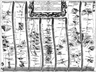
only the first part was completed in its entirety. This was a survey that consisted of a hundred plates
depicting the principal roads (post roads) of England and Wales emanating from London with some of the
important cross roads. The principal roads were shown in strip form with each page consisting of seven
strips in the form of an unwinding parchment scroll.
Each route began from a designated city, town or village starting with the strip at the bottom left of the page
and progressing up the strip to the top. By following the same pattern on adjacent strips, the route led you
to another settlement at the top right of the page. Each strip had a directional compass and distance was
marked in miles and furlongs. Hills, bridges, rivers, county boundaries, fenced and unfenced roads were
shown on each map which had a scale of one inch to the mile. This scale was later adopted as a standard by
the Ordnance Survey whose first work was published in 1801.
This map was the first to establish the statute mile of 1
,
760 yards as a standard measurement throughout the
country. Until this time, although the measurement had been decreed by Statute in 1593, many people still
used the three types of customary or local miles namely: the great, the middle and small mile. Ogilby’s
measurements were later used also for the setting up of milestones along the post roads. The scroll
containing Langham showed it to be ninety six miles from London and was entitled ‘The Extended Road from
Oakham to Richmond in Yorkshire.’
Langham was depicted with a stone bridge over the brook, on the road from Oakham to ‘Milton’ Mowbray, at
a point near the Cold Orton Road. After leaving Langham the map shows nearby Raukes Burow Hill and roads
leading to Whitsonden and Ashwell followed by the ascent and descent of three hills all drawn in great
detail. On the approach to Langham from the South at Berleythorp a wood bridge over a brook is shown near
to where a road from Burley to Braunston crossed. Ogilby’s road maps were an immediate success and he had
every intention of publishing the other volumes. Unfortunately, he died in 1676, the year after ‘Britannia’
was published, and thus the other volumes and parts were never completed. Three issues of ‘Britannia’
appeared in 1675 and another in 1798. There is little doubt that Ogilby, was a visionary and an avant garde
map maker. Indeed, his legacy was such that his road maps were the bench mark for others such as John
Senex (this was a reduced Ogilby’s 1675 map), Thomas Gardner, John Bowen and Emanuel Bowen to emulate.
Although they generally followed Ogilby’s idea they all dispensed with the unwieldy size of his road map and
published theirs, usually in quarto, octavo or pocket size volumes. This move was to satisfy the increasing
numbers of those travelling the roads for pleasure rather than necessity. A man of many talents, Ogilby’s
final endeavours ensured the adoption of the statute mile of 1
,
760 yards as standard and from 1675 on
practically all county maps included roads.
Each individual road map covers two pages of the Volume. In the first edition (1675) there were no plate
numbers. The second state (1675), third state (1675) and fourth state (1698 after Ogilby’s death and printed
for Abel Swale and Robert Morden) all had plate numbers in the bottom right hand corner of each map.
Measurements vary slightly from map to map. However, the following apply to the printed areas of two of
the maps containing Oakham namely: Plate 47 (London to Oakham) measures 17
inches (430mm) across with a
top to bottom measurement of 12
½
inches (316mm) and Plate 48 (Oakham to Barnsley) measures 17
inches
(430mm) across with a top to bottom measurement of 13
inches (330mm).


Langham Village History Group ~ © 1996 - 2025


John Ogilby 1600-1676 by Anthony Wright


![[x]](index_htm_files/close.png "Close")

John Ogilby was born in or near Kirriemuir, Scotland, in
1600 and was a man of many careers. His first venture
was that of a dancing teacher. A fall during a masque
(courtly entertainment), allegedly at Burley on the Hill,
Rutland, made him lame for the rest of his life and ended
that particular vocation. He next became a tutor, then
literary translator, a theatre owner, finally becoming a
printer and publisher. However, his last business came
to an abrupt halt when in 1666 disaster struck and his
premises in Fleet Street were destroyed in the Great Fire
of London. Ogilby emerged from this catastrophe, with
luck on his side, when he became one of the ‘four sworn
viewers’ (surveyors), appointed by the City Corporation,
whose job it was to survey the parts of London destroyed
in the fire and to establish land ownership of those areas.
The resultant plan was published in 1667 at approximately twenty-five inches to the mile.
In 1672, because of Ogilby’s work, King Charles II appointed him as His Majesty’s Cosmographer and
Geographic Printer. Thus, encouraged with such high status patronage, a salary as Royal Cosmographer and
financial help from other quarters, Ogilby pioneered the first major development in road mapping and hence
the first practical road atlas. His idea was to publish five volumes of a world atlas, the last of which, in three
parts was to be entitled ‘Britannia, Volume the First: or, an Illustration of the Kingdom of England and
Dominion of Wales: By a Geographical and Historical Description of the Principal Roads thereof.’ However,
only the first part was completed in its entirety. This was a survey that consisted of a hundred plates
depicting the principal roads (post roads) of England and Wales emanating from London with some of the
important cross roads. The principal roads were shown in strip form with each page consisting of seven
strips in the form of an unwinding parchment scroll.
Each route began from a designated city, town or village starting with the strip at the bottom left of the page
and progressing up the strip to the top. By following the same pattern on adjacent strips, the route led you
to another settlement at the top right of the page. Each strip had a directional compass and distance was
marked in miles and furlongs. Hills, bridges, rivers, county boundaries, fenced and unfenced roads were
shown on each map which had a scale of one inch to the mile. This scale was later adopted as a standard by
the Ordnance Survey whose first work was published in 1801.
This map was the first to establish the statute mile of 1
,
760 yards as a standard measurement throughout the
country. Until this time, although the measurement had been decreed by Statute in 1593, many people still
used the three types of customary or local miles namely: the great, the middle and small mile. Ogilby’s
measurements were later used also for the setting up of milestones along the post roads. The scroll
containing Langham showed it to be ninety six miles from London and was entitled ‘The Extended Road from
Oakham to Richmond in Yorkshire.’
Langham was depicted with a stone bridge over the brook, on the road from Oakham to ‘Milton’ Mowbray, at
a point near the Cold Orton Road. After leaving Langham the map shows nearby Raukes Burow Hill and roads
leading to Whitsonden and Ashwell followed by the ascent and descent of three hills all drawn in great
detail. On the approach to Langham from the South at Berleythorp a wood bridge over a brook is shown near
to where a road from Burley to Braunston crossed. Ogilby’s road maps were an immediate success and he had
every intention of publishing the other volumes. Unfortunately, he died in 1676, the year after ‘Britannia’
was published, and thus the other volumes and parts were never completed. Three issues of ‘Britannia’
appeared in 1675 and another in 1798. There is little doubt that Ogilby, was a visionary and an avant garde
map maker. Indeed, his legacy was such that his road maps were the bench mark for others such as John
Senex (this was a reduced Ogilby’s 1675 map), Thomas Gardner, John Bowen and Emanuel Bowen to emulate.
Although they generally followed Ogilby’s idea they all dispensed with the unwieldy size of his road map and
published theirs, usually in quarto, octavo or pocket size volumes. This move was to satisfy the increasing
numbers of those travelling the roads for pleasure rather than necessity. A man of many talents, Ogilby’s
final endeavours ensured the adoption of the statute mile of 1
,
760 yards as standard and from 1675 on
practically all county maps included roads.
Each individual road map covers two pages of the Volume. In the first edition (1675) there were no plate
numbers. The second state (1675), third state (1675) and fourth state (1698 after Ogilby’s death and printed
for Abel Swale and Robert Morden) all had plate numbers in the bottom right hand corner of each map.
Measurements vary slightly from map to map. However, the following apply to the printed areas of two of
the maps containing Oakham namely: Plate 47 (London to Oakham) measures 17
inches (430mm) across with a
top to bottom measurement of 12
½
inches (316mm) and Plate 48 (Oakham to Barnsley) measures 17
inches
(430mm) across with a top to bottom measurement of 13
inches (330mm).


Langham Village History Group ~ © 1996 - 2025